

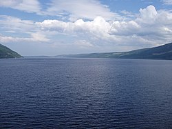
Loch Ness (pronounced /ˌlɒx ˈnɛs/, Scottish Gaelic: Loch Nis) is a large, deep, freshwater loch in the Scottish Highlands (57°18′N 4°27′W / 57.3°N 4.45°W) extending for approximately 37 km (23 mi) southwest of Inverness. Its surface is 15.8 m (52 ft) above sea level. Loch Ness is best known for the alleged sightings of the legendary Loch Ness Monster, also known as "Nessie".

It is connected at the southern end by the River Oich and a section of the Caledonian Canal to Loch Oich. At the northern end there is the Bona Narrows which opens out into Loch Dochfour, which feeds the River Ness and a further section of canal to Inverness. It is one of a series of interconnected, murky bodies of water in Scotland; its water visibility is exceptionally low due to a high peat content in the surrounding soil.
Loch Ness is the second largest Scottish loch by surface area at 56.4 km2 (21.8 sq mi) after Loch Lomond, but due to its great depth it is the largest by volume. Its deepest point is 230 m (755 ft), deeper than the height of London's BT Tower at 189 m (620 ft) and deeper than any other loch with the exception of Loch Morar. It contains more fresh water than all lakes in England and Wales combined, and is the largest body of water on the Great Glen Fault, which runs from Inverness in the north to Fort William in the south.
At Drumnadrochit is "The Loch Ness Exhibition Centre" which examines the controversy through the natural history of Loch Ness. Boat cruises operate from various locations on the loch shore, giving visitors the chance to look for the "monster".
Urquhart Castle is located on the Western shore, 1 mile (1.6 km) west of Drumnadrochit.
The only island on Loch Ness is Cherry Island, visible at its southwestern end, near Fort Augustus. It is a crannog, which is a form of artificial island. (Most crannogs were constructed during the Iron Age.)
There was formerly a second island (Dog Island) which was submerged when the water level was raised during the construction of the Caledonian Canal.
Loch Ness serves as the lower storage reservoir for the Foyers pumped-storage hydroelectric scheme, which was the first of its kind in United Kingdom. The turbines were originally used to provide power for a nearby aluminium smelting plant, but now electricity is generated and supplied to the National Grid. Another scheme, the 100 MW Glendoe Hydro Scheme near Fort Augustus, has recently finished construction and began generation in June 2009 producing 76gigawatt hour in its first months of operation.
Loch Ness lies along the Great Glen Fault, which forms a line of weakness in the rocks which has been excavated by glacial erosion, forming the Great Glen and the basins of Loch Lochy, Loch Oich and Loch Ness.


No comments:
Post a Comment